The Newest Thing at Yarmouth's Second Falls Is Granite Placed to Undo an Old Cut
November 12, 2026
November 12, 2026
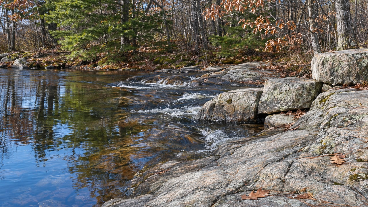
If you stand on the Bridge Street bridge this month and look down at Second Falls, can you tell which parts are the river and which parts people built?
That question got harder to answer this fall. The Royal River Alliance announced on October 27 that the Bridge Street Dam was gone and the Royal River was "once again flowing freely over Second Falls." Most of the dam had been removed by September 29. By the Alliance's count, dams have shaped this river for more than 350 years. Taking the dam away did not leave behind an untouched river. It uncovered bedrock that people had also changed. The newest feature at the falls is a set of granite blocks placed to reverse one of those changes, and once you know where it is, the rest of a walk along the river starts to make sense.
After the dam and its fishway came down, the project team kept monitoring the newly exposed channel. According to the Town of Yarmouth's project updates, the team found that "a previously modified notch in the ledge was creating hydraulic conditions that could impede upstream fish passage."
So the dam was only part of the problem. At some point, someone had cut into the bedrock itself, and with the dam's water gone, the notch sent the river through the steep section in a way that could stop fish from getting upstream. The project team called its response "an adaptive step based on conditions that the project team observed following dam removal."
The town describes the fix this way:
"The rock placement will slow water moving through the steep section of channel, increase the depth of the pool immediately downstream, and restore what was likely an original passage route for upstream migrating fish before the dams were constructed and the bedrock ledge was modified."
The rock came from the project site itself. The town says the granite is being "strategically placed and secured within the river channel at the point where fish passage is most likely to occur." This was not in the original plan. The Maine Department of Environmental Protection, after consulting the Maine Department of Inland Fisheries and Wildlife and the Maine Department of Marine Resources, approved it as a minor revision to the existing project approval on October 14.
Here's how it went:
The town scheduled the work for while Linkel was still on site and expected it to be complete by mid-November. The granite is what you're looking at when you find the steep, fast section of Second Falls and the deeper pool just below it.
Yarmouth has been trying to get fish past Second Falls for a long time. The town built the Bridge Street fishway with the Maine Department of Marine Resources in 1974 and the East Elm Street fishway in 1979. Both were added onto existing dams to help alewives, blueback herring and shad reach their spawning habitat. The issue goes back even further. The Alliance notes that a bill passed in 1834 required fish passage at dams on the Royal River, but functional passage was never enforced.
The fishways never did the job well. The Royal River Alliance FAQ lists the East Elm Street fishway's problems, including an entrance blocked with boulders, a design that doesn't meet standards for shad, and no passage for juvenile eels. The same FAQ puts the 30-year cost of building and maintaining working fish passage at $1.1 million to $1.4 million per dam, with annual fishway maintenance of $16,000 to $20,000 for as long as the dams stand.
Compared with those figures, a few on-site granite blocks are a small fix. If they work, they matter a great deal. The Alliance cites a Trout Unlimited estimate that the watershed's habitat could eventually support about 62,000 river herring and 29,000 American shad. When alewives were stocked in the upper watershed, the count reached 46,485 in 1984. Those figures describe the habitat's long-term capacity, and the Alliance says sea-run fish will return on their own over time, "some species much sooner than others."
Once you've found the granite, the rest of the riverfront shows the same history. Every stretch of this part of the river reflects what people built here and later took apart.
Papermaking started at Second Falls in 1816, when William Hawes and the Cox brothers built a mill on Bridge Street. The brick building now called the Sparhawk Mill went up in 1855 to replace an earlier structure damaged by fire, and it made cotton yarn, cloth and seamless grain bags until 1951. Downstream at the third falls, the Forest Paper Company grew to more than 10 acres, with 10 brick buildings, before it closed in 1923 and burned in 1931. Yarmouth Community Services notes that most of Royal River Park sits on former industrial and mill sites, and its signage and exposed brick remnants show what remains of the Forest Paper complex.
A November loop that covers all of it:
The park's new lighting is set up to run from dusk until no later than 11 p.m. once CMP completes its final inspections. On a weekday morning, Eartha Cafe is open in the former DeLorme building, next to the giant rotating globe. It opened October 12 and keeps hours of 6:30 a.m. to 5 p.m., Monday through Friday.
The project is in its last steps but isn't fully done. A few things will still look like a work site this month:
Upstream, the East Elm Street Dam is still standing. The Royal River Alliance plans to remove it in summer 2027. That would complete the restoration of the lower Royal River and, by the Alliance's figure, reconnect Casco Bay with about 135 miles of river and tributary habitat for migratory fish.
Both dams belong to the Town of Yarmouth. If the Bridge Street work is any guide, removing a dam is only the first step. Each one exposes a stretch of riverbed that people have been changing since the mill era. The Alliance FAQ lists the species most likely to benefit as American shad, alewives, blueback herring, sea-run trout and American eel, along with the egrets, river otters, eagles, ospreys and loons that feed on them. Whether those fish get past Second Falls next spring depends on the granite placed in the notch on October 30.
Here at Dambrie Garon Real Estate Advisors, we keep track of the changes along Yarmouth's river, from the Sparhawk Mill to the new park path. If you have questions about how the village is changing, or how a home near the Royal River fits into it, let's talk about your next move.
Cumberland Maine
What James Baldwin, a dinner at Dara and a possible VA have me thinking about this week.
Fill out the form below to learn more about buying or selling a house in your area.
Dambrie Garon Real Estate Advisors offers their clients particular expertise in the buying and selling of single and multi-family properties, new construction, and subdivision projects. Our clients benefit from our insights into home renovations, knowing where and how much to invest to bring a property to its highest and best use, whether for renovation and resale or renovation for the families' own use.